The community of Trewalchmai is situated about 5 miles from the town of Llangefni on the Isle of Anglesey.
Historically bifurcated into Gwalchmai Uchaf (Upper Gwalchmai) and Gwalchmai Isaf (Lower Gwalchmai), the settlement represents a material record of the transformation of the Welsh landscape from a medieval bardic seat to a modern hub of regional infrastructure. The community is fundamentally defined by its nomenclature, which honors the twelfth-century court poet Gwalchmai ap Meilyr. This historical and linguistic anchor provides a continuous thread that connects the pre-conquest Age of the Princes to the contemporary socio-economic realities of the island.
Geological Foundations and Prehistoric Landscapes
The topographic character of Gwalchmai is a direct consequence of complex geological processes. Sitting at an elevation of roughly 60 meters above sea level, the village occupies a landscape defined by the Caledonian orogeny, manifested in a north-east to south-west corrugated landform. This terrain dictates the drainage patterns of the Afon Ddrudwy, which flows south-west toward the sea.
The underlying geology is predominantly Pre-Cambrian, but the Coedana Granite provides the most significant lithological feature
This granite complex yields a late Precambrian age of approximately 614 million years and constitutes the most extensive outcrop of plutonic igneous rock in the Monian Composite Terrane. The Gwalchmai Quarry is recognized as a Regionally Important Geodetic Site (RIGS) due to its exposures of porphyritic and non-porphyritic granite, which provided primary building materials for many of the village’s oldest structures.
While Gwalchmai is celebrated for its medieval heritage, the surrounding landscape contains evidence of human activity predating the historical record by millennia. Over 120 prehistoric monuments characterize the Isle of Anglesey. In the immediate vicinity of Gwalchmai:
- Llyn Hendref: Drainage works revealed a quern stone and animal bones, indicating early domestic activity.
- Dothan: Assemblages of prehistoric flint tools suggest localized lithic production.
- Cors Bodwrog: A significant Bronze Age hoard of palstaves and socketed axes was discovered in the nearby marshland.
- A55 During the construction of the A55 expressway, a high density of sites was revealed, preserved as buried archaeology beneath the plough soil, suggesting the area was part of a densely populated region of settled farms and ritual centers.
- Roman Coins have been found in Cors Bodwrog and a Roman copper ‘cake’ was found close to Llandrygarn 3km north of Gwalchmai.
The Medieval Era: A Poet’s Legacy
The transition of the settlement into a recognized historical entity is inextricably linked to Gwalchmai ap Meilyr (fl. 1130–1180). His name, which may derive from the Welsh hero Gwalchmei ap Gwyar—the Gawain of Arthurian legend—bestowed upon the village a sense of mythological and literary prestige.
Gwalchmai’s most important work, the Gorhoffedd Gwalchmai (“Gwalchmai’s Boast” or “Gwalchmai’s Praise Poem”), is considered one of the greatest achievements of medieval Welsh literature.
In the poem, the poet celebrates his own military prowess, his experiences in the field, and his courtly life.Sung during the lifetime of his patron, Owain Gwynedd, the poem contains specific historical references to the Prince’s successful military campaigns, including those in South Wales (1136–1138) and around Rhuddlan (c. 1150).
Gwalchmai also boasted of himself being a loyal warrior with the following poem.
“Gwlachmai y’m gelwir,gelyn y saeson.Er lles brenin Mon ymosodais mewyn brwydr”
” Gwalchmai they call me,enemy of the English.For Anglesey’s king I have lunged out in battle”
This work, along with Gwalchmai’s description of the victory at the Battle of Tal Y foel in 1157, was central to his service as a Gogynfeirdd (Poet of the Princes). It was for these poetic services that Owain Gwynedd granted Gwalchmai the township and associated lands of Trewalchmai in Anglesey
The Battle of Tal y Foel: The ode commemorates a conflict that took place around 1158 at Tal y Foel (near the Anglesey coast, opposite Carnarvon). In this battle, Prince Owen Gwynedd defeated three combined fleets of Irish, Danish, and Norman pirates.
As the son of Meilyr Brydydd ,the court poet to Gruffudd ap Cynan at Aberffraw, Gwalchmai used this poem to solidify a poetic and familial legacy in the parish that lasted for centuries. The poem reflects the dual role of the medieval court poet as both a warrior-observer and a lyrical artist.
The original Hendregadredd manuscript (also known as Llawysgrif Hendregadredd) is held today in the National Library of Wales.
Gwalchmai had several sons. Poetry composed by two (or three) of them is extant, viz. Einion and Meilyr ap Gwalchmai and, possibly, Elidir Sais. The Record of Caernarvon reveals the connection of Gwalchmai and his sons with Trewalchmai in Anglesey, and also that three of his sons were named Meilyr, Dafydd and Elidir. In his ‘ Dream,’ Gwalchmai laments the loss of Goronwy, and in a series of elegiac englynion to the retinue of Owain Gwynedd (The Myvyrian Archaiology of Wales , 163b) mention is made of a Goronwy, son of Gwalchmai
The administrative structure of the parish, properly known as Trewalchmai, was built around his descendants. The Record of Caernarvon (1352) reveals that the hamlet contained three gwelyau (family landholding groups) named after his sons: Meilyr, Dafydd, and Elidir. During this period, Trewalchmai was part of the Cantref of Malltraeth.
Another son was Einion ap Gwalchmai ( fl.1203-1223) who’s wife was Angharad ferch Ednyfed Fychan.A portion of an awdl by him to Llywelyn ap Iorwerth mentions that prince as fighting against the English, and was therefore probably composed after the turn of the century. He also composed a beautiful elegy to Nest, daughter of Hywel, of Towyn, Meironnydd, and three awdlau to God. In one of these he refers to his intention to go on a pilgrimage over the Alps to the Holy Land. References in his poems indicate that he had been prominent in the courts of Welsh princes, but that after the ‘service of chieftains’ he felt drawn to the praising of God, and he states that ‘blessed are monks in churches.’ He wishes to end his days in Bardsey, and in another pious awdl there is the suggestion that he became a monk, for he sings, ‘Let us keep the midnight devotions, according to the practice. Let us not sleep, let us chant the canonical prayers.’ His religious poems, like his elegy to Nest, are melodious and graphic, and it is evident that in his day he was a popular poet.
Another indication of his popularity is to be found in the fact that he became a character in folk-lore. A tale is told of his having made a leap of fifty feet at Abernodwydd in the presence of his beloved when he was a young man, and according to another tale he went on pilgrimage, remained away from home for twenty-one years, and on returning immediately after the marriage of his wife (who, according to the story, was Angharad, daughter of Ednyfed Fychan), was recognized by her on playing the harp and producing half the wedding ring which he had kept. There is another tale of his being cured by ‘ Friar Gwryd ‘ of a seven years’ affliction. In an englyn in which part of the second tale is told
In addition to the poet’s lands, the Bishop of Bangor held significant properties. A 1306 survey indicates the Bishop held four carucates (approximately 200 acres) in Trewalchmai, farmed by 24 tenants. Central to this holding was Ysgubor Esgob (the Bishop’s Barn), a farm that likely served as a grain store for ecclesiastical tithes.
Ysgubor Esgob – Referred to in a document in 1306 as the property of the Bishop of Bangor, and also in a document in 1700 as the property of Penrhos Estate.
Within the medieval parish were located both a free medieval hamlet belonging to the descendants of Gwalchmai and lands belonging to the Bishop of Bangor. The name of the parish and township is derived from Gwalchmai ap Meilyr (fl 1130-80), a poet from a family of some local importance. Meilyr, Gwalchmai’s father, was also a poet, and at least two of Gwalchmai’s sons, Einion and Meilyr, were poets, whilst Einion was also a man of the law, possibly a magistrate, in the service of Llywelyn
ap Iorwerth.
The medieval extent of 1352 lists a number of townships and hamlets
belonging to descendants of the family, including the hamlet of Trewalchmai which it describes as containing three gwelyau or family groups named Gwely Meilir ap Gwalchmai, Gwely Dafydd ap Gwalchmai and Gwely Elidir ap Gwalchmai, i.e. they are named after three of the sons of Gwalchmai.
In 1352 the hamlet was occupied by their descendants, who had shares in both the land and in a corn water mill. One part of the hamlet was described as ffridd in the lord’s hand, the likelihood being that one part owner had died without an heir.
Trewalchmai is also named in another medieval extent dated 1306 which described the lands of the Bishop of Bangor. The Bishop’s holding consisted of 4 carucates of land (perhaps some 200 statute acres) farmed by 24 tenants. In 1545 the freeholders of the vill of ‘Trewalchmaye, belonging to Bishop of Bangor’ requested in the Court of Augmentations that the boundary between their vill, or township, and the adjoining vill
of Trevybian Meryc be established, as the vills are ‘so nigh together and divided by metes and bounds so uncertain and unknown how far they should extend or where to sever or part’.
The boundary referred to lies on the edge of the parish, but it shows
that the Bishop’s lands were not in a cohesive block around the church, but scattered throughout the arish, and presumably intermingling with the freehold lands of the descendants of Gwalchmai ap Meilyr.
Another historical landmark, the Spite Inn, derives its name from the Roman Hospitium, indicating a medieval guest house or hotel existed there for travelers.Historical Ownership of Spite Inn: In the 18th century, maps recorded the Spite Inn area as “Poor land,” and by the 19th century, it was described as belonging to the “Poor of Llangefni“. It is located to the north of the farm known as Ysgubor Esgob.
Hendref – There is a stone at Hendref with the letters and date OH1675 chiselled into it. The exact same letters, but with 1674 as the year, have been chiseled into a stone at the bottom of a window in the Parish Church.
St Morhaiarn’s Church is the oldest building in the parish and the primary physical link to its medieval past. Designated as a Grade II* listed building, it is recognized as an edifice of national historical importance. The church is situated at the end of a single-track lane in what was the original core of Gwalchmai Uchaf.
The church is dedicated to St (Mor)haiarn (variants in sources include Morhaiarn / Morhaearn); very little reliable information survives about the saint himself and the dedication appears to be of local rather than wide-ranging early medieval fame. However some historians propose it is a variation of Mordeyrn, the saint associated with Nantglyn church in Denbighshire
Key architectural features include:
- Twelfth-Century Origins: The modern north doorway appears to incorporate stone voussoirs from a 12th-century arch, suggesting a structure existed during the lifetime of Gwalchmai ap Meilyr.
- Fourteenth-Century Core: The continuous nave and chancel date from the 1300s.
- The North Chapel (c. 1500): This addition is divided from the chancel by an arcade of two four-centered arches.
- The 1674 Reconstruction: The chancel and nave were rebuilt in the late 17th century; a carved stone in a window bears the date 1674 and the initials OH, matching a stone at the nearby farm of Hendref.
- Nineteenth-Century Renovations: Extensive renovations were conducted in 1845 by Reverend J. Wynne Jones.

There is a window stone in the Church which bares the Inscription “OH 1674”.

A similar stone and inscription can be seen on the outside of the church. There is also a stone with the same initials and date in a local house called Hendre. The grave below is said to belong to OH. This may be for Owain ab Owain (Hughes) who was born in Hendre , a house in the village in 1635.


The “lost well” lore in Gwalchmai is centered on a historical feature known locally as “The Church Well,” located on the grounds of St Morhaiarn’s Church. While the well is now physically absent, it remains a point of historical interest for the community.
The well was once a recognized and functional landmark in the village. It was formally recorded on early cartographic surveys, most notably the 1888 Ordnance Survey Map. Its presence on such maps indicates it was a vital point of reference for the parish during the 19th century.
Despite its proximity to an ancient church with 12th-century foundations, the lore suggests that the well was unlikely to have been a “holy well”. In the context of North Wales, where many ancient wells were celebrated for healing properties or associated with specific saints, “The Church Well” appears to have been more utilitarian in nature.
The well earned its “lost” status because it was filled in many years ago, leaving no visible trace on the surface today. Its memory has been preserved primarily through archival research and local oral history.
In 2025, the Trewalchmai Community Council applied to extend the burial ground into neighboring agricultural land to ensure continued service for the community. During archeological exploration of the possible site a number of “Cist” graves were discovered.
The Transport Revolution: Telford and the A5
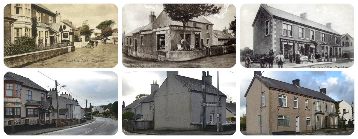
The modern identity of Gwalchmai was reshaped by the construction of the London-to-Holyhead road (now the A5) between 1815 and 1826.
Following the Act of Union in 1801 a programme to improve the roads between the two capital cities of London and Dublin was initiated. In 1811 Thomas Telford was commissioned to undertake a survey of the roads between London and Holyhead and in 1817 began work on the northern stretch of the road at Shrewsbury. Work started on Anglesey in 1818 and 5 tollhouses, designed by Telford, were built across the island. In 1844 a law was passed abolishing tolls from Holyhead to Shrewsbury but an exemption was made of the tollhouses of Anglesey where charges were actually increased and proved adequate for the maintenance of the roads for several years. In 1895 the exemption ended and on 28th November the tollhouses were sold
This project, led by engineer Thomas Telford, was the first major civilian state-funded road project since Roman times. The road was designed to facilitate rapid mail coach travel to Ireland, requiring a maximum gradient of 1:17.
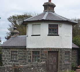
This engineering requirement caused the new road to bypass the original village center of Gwalchmai Uchaf. Consequently, a new settlement, Gwalchmai Isaf (Lower Gwalchmai), developed rapidly along the A5. This transformation included the construction of a turnpike (tollgate) around 1820. Passing through with a horse and cart cost three pennies until the toll was abolished in 1895. The proximity to this major arterial route transformed Gwalchmai from a quiet agricultural parish into a vital waypoint on a key transport corridor.
The completion of the stage between Holyhead and Menai Bridge saw all the milestones across Anglesey and into Bangor erected between 1825 and February 1826.

However it also resulted in a change to how law was enforced by the local police.
Industrial Mechanics: Wind, Water, and Granite
In the 19th century, Gwalchmai developed a modest industrial base. The village supported both wind and water power for milling:
- Melin Gwalchmai: This windmill, built in the early 19th century on the Treveilyr Estate, was operated for decades by the Williams family. In 1927, a severe storm destroyed its sails and cap. Afterward, it was powered by a diesel engine in an adjacent shed, with the drive shaft running through a cellar to the millstones. (More info)

- River Ddrydwy Water Mill: Also known as Afon Felin, this mill was built at the start of the 19th century. It processed grain and, remarkably, produced electricity for the village until 1946. The 3rd child from the front in the picture below was called Nell Lewis.

Surveys conducted in the 1970s revealed the physical remains of the infrastructure:
- Structure: The mill near the church survived as an unroofed stone building measuring 8.2m by 4.9m
Machinery: It featured a wheel pit on the north side that once accommodated an overshot wheel approximately 0.9m wide.
Water Source: The local stream course feeding the mill had been deepened through the former mill pond by the time of modern surveys.
Social and Cultural Evolution: Faith, Education, and Commemoration
Gwalchmai has maintained a resilient community identity, with 75% of the population recorded as Welsh speakers in the 2001 Census. The 18th and 19th centuries saw a rise in Non-conformity, leading to the construction of rival chapels:
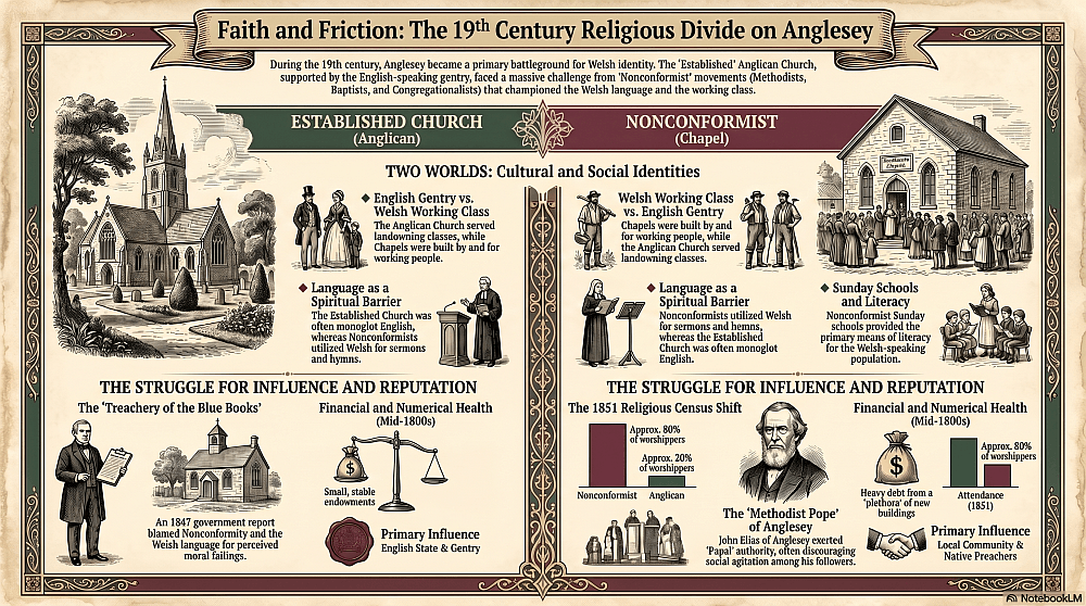
- Jerusalem Chapel: Established in a cottage in 1780 before being fully rebuilt as a chapel in 1849 and restored1925 used by Presbyterian Church of Wales. (More info)
- Moriah Chapel: Opened Easter 1847 when it costs £120 to build ; a new, larger chapel was built directly opposite it in 1902.Welsh Independent / Congregational
- Baptist Tabernacle Church: Built in 1890, it now serves as a center for the village’s pensioners.

The hymn tune Gwalchmai has a distinctly Welsh 19th-century origin and is best known today as a setting for the hymn words “King of Glory, King of Peace” (from a 1633 poem by the English poet and priest George Herbert) in many hymnals.The composer was Joseph David Jones, a Welsh musician born in 1827 in Bryngrugog, Montgomeryshire.
The tune Gwalchmai was first published in 1868, just two years before Jones’s death in 1870. At that time he was headmaster of a school he had founded in Ruthin, Denbighshire (Wales). The origin of the name Gwalchmai itself is obscure, but it’s likely taken from the name of the village of Gwalchmai on the Isle of Anglesey in Wales. The place name is also linked linguistically to medieval Welsh/Arthurian names like Gwalchmai (the Welsh form of Gawain).
The National School, which was opened in 1856, was the first school in the village, and managed by the Church of England. There were 43 children attending regularly. In competition, a British School was opened in Upper Gwalchmai a few months thereafter.Today, the village school is called Ysgol y Ffridd and has capacity for 96 children.
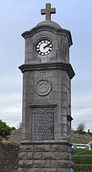
The village’s sacrifice in the world wars is commemorated by the Gwalchmai War Memorial, a landmark clock tower built in 1926 by stonemason John Griffiths. It is inscribed with the names of 29 local men lost in World War I and 9 who died in World War II
More information about the war memorial
More information about Gwalchmai and the World Wars
In 1974, the Anglesey Agricultural Society purchased the farm of Glan Gors Ddu in Gwalchmai, establishing a permanent 160-acre showground. Since 1975, this has been the home of the Anglesey County Show, which attracts up to 60,000 visitors annually and has become a central pillar of the island’s cultural life. In 2026, the showground is scheduled to host the Urdd National Eisteddfod, Europe’s largest youth festival.
More information on the show ground
https://www.urdd.cymru/en/eisteddfod
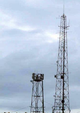
The telecommunications infrastructure in the historic village of Gwalchmai represents a vital link in the regional network, blending mid-20th-century origins with modern digital requirements. The site consists of two primary components: the physical telephone exchange building and a nearby communications mast, both of which have evolved to serve the changing needs of the community.

Recent community projects, such as Rural Futures, working with a community based group called “Hwb Gwalchmai” have worked to capture the aspirations of Gwalchmai’s residents. A 2021 “Youth Vision” project encouraged local children to imagine the future of their village.
https://www.facebook.com/groups/683321615641592
Their ideas included a colorful Gwalchmai with free food for those in need, robots for community maintenance, and a “magical relationship” with the land. While facing modern challenges like heavy traffic on the A5 and a lack of affordable housing, the village remains a close-knit community characterized by mutual support and a strong sense of Cynefin.
Gwalchmai has a village shop with Post Office
https://www.facebook.com/profile.php?id=100057361243086
And a mechanic/car sales business. These commercial amenities are primarily located in Gwalchmai Isaf (Lower Gwalchmai), a settlement that developed rapidly following the construction of Thomas Telford’s A5 road.
The village pub in Gwalchmai is known as the Gwalchmai Hotel.
https://www.facebook.com/thegwalchmaihotel
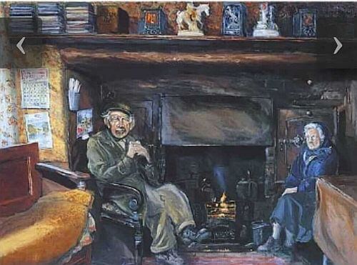
Bryn Golau, Gwlachmai
John Parry – or John Parry Moch as he was better known – didn’t have electricity on the farm where he’d lived his whole married life with his wife and children.
So you don’t have any electricity in the house?” he was asked.
Wel yr Arglwydd, nag oes!” he replied emphatically.
“I went to some farm, a long time ago, and electricity had killed all the cows.”
There is a slate sign near Plas Cwmorthin near Blaenau Ffestiniog which has his name on it as part of a verse to characters from Gwlachmai.
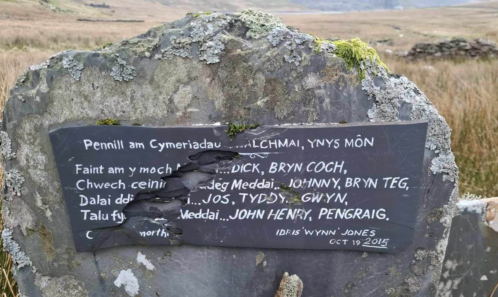
Johnny Parry Brynteg aka Johnny moch lived on a smallholding up by the clock.
Jos Tyddyn Gwyn was a ‘hwsmon’ someone who moved cattle.
John Henry Pengraig was the owner of the horse livery straight ahead at the top crossroads. His son Gwyn now runs the place.
Local sporting clubs.