

The first turnpike roads across Anglesey were built from the 1760s onward, with smaller local routes initially. Turnpike roads were main roads maintained by trusts funded through tolls. On Anglesey they were linked by ferry to the mainland
From 1718 the post road ran directly from Porthaethwy to Penmynydd, and through Ceint, Bodffordd and Bodedern to Holyhead. By mid-century milestones were placed for the convenience of the light horse-drawn carriages now in vogue. Gwyndy, Llandrygan, built in 1758, became an important coaching inn acclaimed for its hospitality. It was here that the leading gentry, Bayly, Bulkeley and Panton, met in January 1760 to petition parliament for a turnpike-road. Trustees authorized to take over responsibility recouped their expenditure by charging tolls. Sanctioned by the Anglesey Turnpike
Act of 1765, the 26-mile post road was generally widened and improved and toll-gates erected at Braint, Llangefni, Llanynghenedl and Holyhead.
The history of Thomas Telford’s A5 road across Anglesey is defined by its role as a revolutionary communication link between London and Dublin, constructed following the Act of Union in 1800 to facilitate the rapid transport of Irish mail. While earlier routes existed, they were notoriously dangerous and inefficient; Telford’s project, authorized by the Holyhead Roads Act of 1815, created a direct, state-funded road that remains a landmark of civil engineering.
Telford’s road across Anglesey was built between 1818 and 1826. His design utilized a “Roman manner,” prioritizing deep structural integrity rather than just a superficial surface.
It replaced an older turnpike road.
- The Structural Layers: The road consisted of a hand-set bottom layer of large stones (7–9 inches deep), a middle layer of smaller graded stones, and a final coating of smooth pebbles or gravel.
- Gradient Control: To ensure mail coaches could maintain speed with “military punctuality,” Telford mandated that gradients never exceed 1 in 17 (5.9%).
- Drainage: The surface was cambered (raised in the center) to allow water to shed into side drains, a critical feature for the wet North Wales climate.
Impact on the Gwalchmai Area
The arrival of the A5 around 1820 fundamentally reshaped the communal geography of Gwalchmai.
- Ribbon Development: The new road bypassed the original village nucleus on higher ground (now Gwalchmai Uchaf, or Upper Gwalchmai). This led to a “ribbon development” known as Lower Gwalchmai (Gwalchmai Isaf) directly alongside the A5, which grew to serve travelers and road workers.
- The Gwalchmai Toll House: To fund the road, a toll gate was established at Gwalchmai, charging roughly three pennies for a horse and cart.
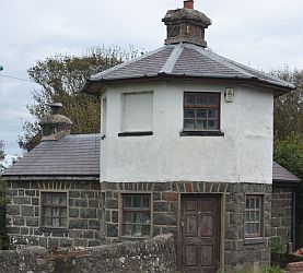
The Gwalchmai Toll House was built around 1820 as a critical component of Thomas Telford’s A5 Holyhead Road project. Its history and financial structure were tied to the state-funded effort to maintain rapid communication between London and Dublin following the Act of Union
- Strategic Placement: The toll house was one of five gates established across Anglesey at approximately five-mile intervals. Like other Telford toll houses, it was strategically positioned at a junction where an existing road met the new “state-of-the-art” highway.
- Architectural Role: Telford’s toll houses were designed to be both functional and elegant, often utilizing symmetrical or octagonal plans to allow collectors a 360-degree view of approaching traffic.
- Socio-Economic Impact: The construction of the toll house and the A5 triggered a shift in the local geography, creating a new “ribbon development” known as Lower Gwalchmai (Gwalchmai Isaf). This new section of the village grew specifically to serve the road and its travelers, moving the parish’s economic center away from the original medieval nucleus around the church.
- Operational Longevity: While tolls were abolished in many parts of the UK by 1844, they were extended on Anglesey until 1895 to fund ongoing road maintenance. After this period, the toll house was sold and eventually converted into a private residence, which still stands today.
- Passage Costs: The standard fee for a horse and cart to pass through the Gwalchmai gate was approximately three pennies.
- The Mail Coach Priority: Mail coaches were the elite users of the road and operated with “military punctuality”. As a coach approached, the guard would sound a post-horn to signal the toll-keeper.
- Strict Penalties: Toll-keepers were legally required to open the gates promptly for the mail; failure to do so resulting in a delay to the post could lead to the toll-keeper being fined
- Mona Inn: Located just east of Gwalchmai replaced the coaching house at Gwyndy on the all turnpike road.Telford built this purpose-built coaching hub in 1821. It was an exceptional complex featuring a large cobblestone courtyard and a five-bay lofted coach house designed for maximum efficiency during mail coach “pit stops”. It famously hosted the Anglesey Hunting Club in 1822–23 before being converted to a farm in 1851 after the railway arrived.
The Mona Inn (also known as Mona Isaf) is a purpose-built coaching facility located at Mona, Boddfordd, on the Isle of Anglesey. Commissioned by Thomas Telford as an integral component of the A5 London-to-Holyhead Post Road, it was completed in 1821 to serve as a elite staging post for the Irish Mail.
Designed to signal the state’s presence in the landscape, the main building was constructed with the appearance of a small gentry house.
- Main Residence: The inn is a two-storey, five-window range building with brick-vaulted cellars, constructed of local rubble masonry with rendered elevations.
- Original Interiors: It retains many original features, including hornless sash windows with panelled shutters, a stone flagged floor in the central hallway, and a dog-leg staircase.
- Ancillary Wings: A shorter two-storey wing on the northwest end, known as Mona Isaf, served as the innkeeper’s private residence.
- Walled Orchard: To the rear of the outbuildings lies a walled orchard containing apple trees from the coaching period.
The Mona Inn was a sophisticated “pit stop” designed for maximum transport efficiency.
- Cobblestone Courtyard: To the rear is a large, fully enclosed cobblestone courtyard.
- The Coach House: The courtyard is dominated by a lofted five-bay coachhouse featuring ashlar heads and shallow elliptical arches, designed to allow mail coaches to be serviced and exchanged with “military punctuality”.
- Stables and Accommodation: The complex included U-shaped ranges of lofted stables with servants’ accommodation on the first floor to ensure a constant supply of grooms and hostlers for the mail teams.
- Social Hub: Beyond its logistical role, the inn hosted high-society events, such as the meetings of the Anglesey Hunting Club in 1822–23.
The success of the Mona Inn was short-lived due to the arrival of the railway.
- Shift to Rail: Following the completion of the Chester to Holyhead railway in 1848 and the Britannia Bridge in 1850, mail traffic was diverted away from Telford’s road.
- Conversion to Farming: By 1851, the inn had ceased its primary function and became known as Mona Farm.
- Preservation: The complex was recognized for its exceptional historical interest and designated as a listed building* by Cadw in 1998.
- Renovation: After being partially inhabited in the 1980s, the property became a major renovation project with approved plans to convert the structure into a grand country residence.
Milestone 13, a standard Telford limestone pillar, stands directly opposite the old coaching house, though the inscription for the distance “from Mona” was left blank because the milestone was already at the staging post
- Later Logistical Use: The Gwalchmai corridor remained strategically important; during World War II, a Prisoner of War camp for Italian and Polish prisoners was established between Gwalchmai Uchaf and the A5.
Roadside Features and Sentinels
The road was equipped with standardized “furniture” that remains largely intact today.
- Milestones: All milestones across Anglesey were erected between 1825 and 1826. Milestone 10, located west of Gwalchmai, is a listed dressed limestone pillar showing distances to Holyhead (10 miles), Mona (3 miles), and Bangor (15 miles). Many of these stones have “shrunk” over time, with up to 60% of their height buried by successive road resurfacing.

- Material Depots: Approximately 300 semi-circular roadside recesses (depots) were built to store grit and gravel. Telford strategically placed these on the sunniest side of the road to keep the materials dry and frost-free for winter repairs.
The Final Links and Decline
The road across Anglesey was joined to the mainland by the completion of the Menai Suspension Bridge in 1826, then the largest-span suspension bridge in the world. At the other end, Telford built the Stanley Embankment (known as “the Cob”) in 1822–23, creating a direct path to Holy Island.
Despite its brilliance, the A5’s dominance as a mail route was short-lived; by 1848–1850, mail traffic shifted to the new railway line. However, Telford’s foundation was so robust that it remained the island’s primary artery for over 175 years until the completion of the A55 Expressway in 2001. Today, about 40% of the original Telford features survive, and the route is designated and preserved as a “Historic Route”